

Navionics
Navionics NAUS001L - U.S. & Coastal Canada - Navionics+
Navionics NAUS001L - U.S. & Coastal Canada - Navionics+
SKU:OM-NAVIONICS-NAUS001LUS-010C136630
Low stock: 3 left
Couldn't load pickup availability

Overview
Navionics NAUS001L U.S. and Coastal Canada Navionics+ is an SD/MSD chart card for compatible chartplotters. It combines nautical chart coverage, SonarChart HD bathymetry, community edits, route guidance, live mapping, and update features for coastal and inland boating.
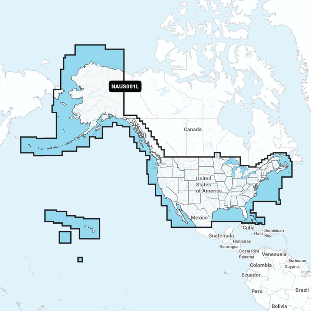
Coverage includes U.S. coasts, lakes, rivers, and inland waterways, plus Alaska and Hawaii. Canadian coverage includes coastal British Columbia, the Great Lakes, the St. Lawrence Seaway, New Brunswick, and Nova Scotia, with additional coverage for Bermuda, the Bahamas, Baja California, the Gulf of California, Johnston Atoll, and Palmyra Atoll/Kingman Reef.
- Chart code: NAUS001L
- Product type: Navionics+ marine cartography
- Format: SD/MSD card
- Included: SD/MSD card
- Coverage: Entire U.S. coasts, lakes, rivers, inland waterways, Alaska, and Hawaii
- Canada coverage: Coastal British Columbia, Great Lakes, St. Lawrence Seaway, New Brunswick, and Nova Scotia
- Additional coverage: Bermuda, Bahamas, Baja California, Gulf of California, Johnston Atoll, and Palmyra Atoll/Kingman Reef
- Nautical Chart: Charts derived from official, government, and private sources
- SonarChart HD Bathymetry: 1 ft / 0.5 m bathymetry charts
- Community Edits: Local edits from users of the Navionics Boating app on a compatible smart device
- Daily Updates: Up to 5,000 daily chart updates
- Route guidance: Dock-to-dock route guidance provides a suggested path
- Live mapping: SonarChart Live Mapping displays new HD depth maps in real time as the boat moves
- Map controls: Advanced Map Options for customizing the chart view
- Plotter Sync: Transfers routes and markers and updates chart layers between a compatible chartplotter and the Boating app
- Compatibility: Check Navionics+ content and feature compatibility with your GPS chartplotter
Specifications
| Brand | Navionics |
|---|---|
| Manufacturer part # | 010-C1366-30 |
| UPC | 8056780000572 |
| Boxed dimensions | 6 x 4 x 1 in |
| Shipping weight | 0.2 lb |
| Country of origin | UNITED STATES |
Manuals & documents
Shipping & returns
Fast, tracked shipping
In-stock orders ship quickly with tracking. Oversized and freight items may ship separately and can take a little longer.
Non-returnable item
This item cannot be returned once ordered, except where it arrives defective, damaged, or shipped in error. Please check fitment and specifications carefully before ordering. See our refund policy.
Authorized dealer
OutdoorsMarine is an authorized Navionics dealer. Every product is genuine and backed by the full manufacturer warranty.
Frequently bought together
Similar items you may like
Popular in Cartography
Top deals right now
Authorized dealer
Genuine products, full warranty.
Fast, tracked shipping
On in-stock marine gear.
Expert support
Talk to people who know the gear.
Secure checkout
Protected payments via Shopify.